

RobertSchneiker.com

From 2.6 million to 11,700 years ago, Earth was in an ice age. Global temperatures were 5–10°C (9–18°F) colder than now. During
the last glacial maximum continental ice sheets covered much of the Northern Hemisphere; in places the ice was 3.2 km (2
miles) thick. With so much water locked up on land sea level fell up to 120 m (400 ft).
As ocean level fell, so did the Nile River, flushing out the soft sediments, exposing the upper section of the ancient canyon. The
Nile canyon was refilled with river sediments as ocean level rose at the end of the ice-age. The upper section of the Nile canyon
has been exposed and refilled many times as sea level fluctuated between glacial and interglacial periods.
In response, groundwater levels at Giza have fluctuated. At times, the limestone that would be used to make the Sphinx was
soaked in groundwater. At other times, the water table dropped hundreds of feet. Each wetting and drying cycle created a small
amount of stress. Much like metal fatigue, the repeated stress weakened the limestone bedrock. Alternating between wet and
dry conditions made the limestone weaker than if it had remained wet.
Simply mixing CO
2
with water creates carbonic acid.
Following bedding planes and fractures, the acidic
groundwater weathered the limestone, weakening it.
Over time, the carbonic acid dissolves the limestone.
If continued long enough, this process produces caves
as seen in the Major Fissure that crosses the Sphinx
body just in front of the rear paws.
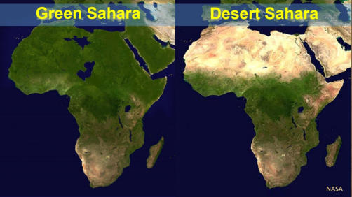
Green Sahara Periods
Today the Sahara looks like a place where it may have rained once a million years ago. Intimidating and foreboding, the lifeless desert quietly belies its past. As unlikely as it seems the Sahara was a green savanna, not just once, but time and time again. The Green Sahara, in greater and lesser incarnations, has appeared then vanished at least 230 times over the past 8 million years. Driven by slight perturbations in Earth’s axial tilt and orbit, the Sahara has been switching between desert and savanna conditions roughly every 20,000 years, for at least the past 20 million years. Green Sahara Periods occur whenever the Northern Hemisphere summer coincides with Earth’s closest orbital approach to the sun. This produces slightly hotter summers, causing more hot air to rise. As the hot air rises, it is replaced by cooler air at the surface, drawing the African monsoons northward, turning the Sahara green. During a Green Sahara Period, North Africa receives substantially more precipitation than it does now. It even contained the world's largest lake named Mega Chad. At its peak, this lake had a surface area of 361,000 km 2 (140,000 miles 2 ), more than 4.5 times the size of Lake Superior. Prior to construction of the Aswan Dam, the pulse of summer monsoon precipitation that fell in Ethiopia did not reach Cairo until late summer to early fall. The delay was caused by the great distance the flood waters had to travel to reach Cairo. During a Green Sahara Period, Nile River year-round flows would have been more consistent throughout the year, as summer monsoon precipitation that fell in Northern Egypt fed the Nile. The last Green Sahara Period, known as the African Humid Period, began at the start of the Bølling-Allerød about 14,600 years ago. The Sahara briefly returned to desert conditions during the Younger Dryas cooling. Then 11,700 years ago, as the ice age ended, the Sahara once again turned green.Hunter-Gatherers
Today the Sahara is one of the most inhospitable places on earth. However, recent archaeological, botanical, and geological evidence indicates that during the early Holocene hunter-gatherers thrived throughout the Sahara. That people survived and even thrived in a desert larger than the United States seems impossible. Between 12,000–5,500 years ago the Sahara was a green savanna with abundant precipitation. Creating favorable conditions for hunter-gathers throughout the Sahara. Hundreds of archaeological sites documenting human occupation of the Sahara during the African Humid Period have been discovered. No one can say how many more sites remain undiscovered.Rock Art
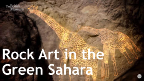
Like other ancient cultures the people left a record of their past. Ancient rock art spans the Sahara, from north to south and east to west. It is the legacy of thousands of years of occupation when hunter- gatherers thrived throughout the Sahara. There is so much rock art that the Sahara has been described as the world’s largest open-air art gallery. Some of the rock art is painted, elsewhere it is carved in the rock. There are humans with animal heads, reminiscent perhaps of hieroglyphic depictions of Egyptian gods. Elsewhere there are depictions of aurochs (the ancestor of domestic cattle), lions, hippopotamus, crocodiles, giraffes and other animals. Some are crude figures, others sophisticated art. It is the work of countless generations over thousands of years. The rock art bears testimony to a very different climate from what we see today. Although exposed to the elements for the past 5,000–12,000 years, the rock art shows little sign of erosion. At Qurta, 800 km (500 miles) south of Cairo, the rock art was dated using optically stimulated luminescence to be at least 15,000 years old, making it Pleistocene in age. It is the oldest rock art in all Northern Africa, yet it shows very little, if any erosion.Desert Sahara Periods
Desert Sahara Periods occur whenever the Northern Hemisphere winters coincide with Earth’s closest orbital approach to the Sun. This makes for slightly warmer winters and slightly cooler summers. Cooler summers means less hot air rises. As a result, the weak surface winds fail to draw the monsoons northward. It is a drought that lasts for thousands of years, making the Sahara a difficult, if not impossible, place for humans to live.


Icehouse Earth
Pleistocene-Holocene: 2.6 million-5,000 years ago


Mysteries of the
Great Sphinx


© Robert Adam Schneiker 2023
RobertSchneiker.com
From 2.6 million to 11,700 years ago, Earth was in
an ice age. Global temperatures were 5–10°C
(9–18°F) colder than now. During the last glacial
maximum continental ice sheets covered much of
the Northern Hemisphere; in places the ice was 3.2
km (2 miles) thick. With so much water locked up on
land sea level fell up to 120 m (400 ft).
As ocean level fell, so did the Nile River, flushing out
the soft sediments, exposing the upper section of
the ancient canyon. The Nile canyon was refilled
with river sediments as ocean level rose at the end
of the ice-age. The upper section of the Nile canyon
has been exposed and refilled many times as sea
level fluctuated between glacial and interglacial
periods.
In response, groundwater levels at Giza have
fluctuated. At times, the limestone that would be
used to make the Sphinx was soaked in groundwater.
At other times, the water table dropped hundreds of
feet. Each wetting and drying cycle created a small
amount of stress. Much like metal fatigue, the
repeated stress weakened the limestone bedrock.
Alternating between wet and dry conditions made
the limestone weaker than if it had remained wet.
Simply mixing CO
2
with water creates carbonic acid.
Following bedding planes and fractures, the acidic
groundwater weathered the limestone, weakening
it. Over time, the carbonic acid dissolves the
limestone. If continued long enough, this process
produces caves as seen in the Major Fissure that
crosses the Sphinx body just in front of the rear
paws.
Green Sahara Periods
Today the Sahara looks like a place where it may have rained once a million years ago. Intimidating and foreboding, the lifeless desert quietly belies its past. As unlikely as it seems the Sahara was a green savanna, not just once, but time and time again. The Green Sahara, in greater and lesser incarnations, has appeared then vanished at least 230 times over the past 8 million years. Driven by slight perturbations in Earth’s axial tilt and orbit, the Sahara has been switching between desert and savanna conditions roughly every 20,000 years, for at least the past 20 million years. Green Sahara Periods occur whenever the Northern Hemisphere summer coincides with Earth’s closest orbital approach to the sun. This produces slightly hotter summers, causing more hot air to rise. As the hot air rises, it is replaced by cooler air at the surface, drawing the African monsoons northward, turning the Sahara green. During a Green Sahara Period, North Africa receives substantially more precipitation than it does now. It even contained the world's largest lake named Mega Chad. At its peak, this lake had a surface area of 361,000 km 2 (140,000 miles 2 ), more than 4.5 times the size of Lake Superior. Prior to construction of the Aswan Dam, the pulse of summer monsoon precipitation that fell in Ethiopia did not reach Cairo until late summer to early fall. The delay was caused by the great distance the flood waters had to travel to reach Cairo. During a Green Sahara Period, Nile River year-round flows would have been more consistent throughout the year, as summer monsoon precipitation that fell in Northern Egypt fed the Nile. The last Green Sahara Period, known as the African Humid Period, began at the start of the Bølling- Allerød about 14,600 years ago. The Sahara briefly returned to desert conditions during the Younger Dryas cooling. Then 11,700 years ago, as the ice age ended, the Sahara once again turned green.Hunter-Gatherers
Today the Sahara is one of the most inhospitable places on earth. However, recent archaeological, botanical, and geological evidence indicates that during the early Holocene hunter-gatherers thrived throughout the Sahara. That people survived and even thrived in a desert larger than the United States seems impossible. Between 12,000–5,500 years ago the Sahara was a green savanna with abundant precipitation. Creating favorable conditions for hunter-gathers throughout the Sahara. Hundreds of archaeological sites documenting human occupation of the Sahara during the African Humid Period have been discovered. No one can say how many more sites remain undiscovered.Rock Art
Like other ancient cultures the people left a record of their past. Ancient rock art spans the Sahara, from north to south and east to west. It is the legacy of thousands of years of occupation when hunter- gatherers thrived throughout the Sahara. There is so much rock art that the Sahara has been described as the world’s largest open-air art gallery. Some of the rock art is painted, elsewhere it is carved in the rock. There are humans with animal heads, reminiscent perhaps of hieroglyphic depictions of Egyptian gods. Elsewhere there are depictions of aurochs (the ancestor of domestic cattle), lions, hippopotamus, crocodiles, giraffes and other animals. Some are crude figures, others sophisticated art. It is the work of countless generations over thousands of years. The rock art bears testimony to a very different climate from what we see today. Although exposed to the elements for the past 5,000–12,000 years, the rock art shows little sign of erosion. At Qurta, 800 km (500 miles) south of Cairo, the rock art was dated using optically stimulated luminescence to be at least 15,000 years old, making it Pleistocene in age. It is the oldest rock art in all Northern Africa, yet it shows very little, if any erosion.Desert Sahara Periods
Desert Sahara Periods occur whenever the Northern Hemisphere winters coincide with Earth’s closest orbital approach to the Sun. This makes for slightly warmer winters and slightly cooler summers. Cooler summers means less hot air rises. As a result, the weak surface winds fail to draw the monsoons northward. It is a drought that lasts for thousands of years, making the Sahara a difficult, if not impossible, place for humans to live.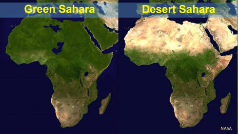


Icehouse Earth
Pleistocene-Holocene: 2.6 million-5,000 years ago


Mysteries of the
Great Sphinx

